
Table of Contents
- In Summary
- Is the Guadalhorce Valley safe from fires?
- Our personal perspective
- Coín's fire history in context
- What the latest 10-year local record shows
- The Sierra de Mijas fire
- Málaga compared with other Spanish property markets
- Spain's difficult 2026 wildfire season
- Why some fires become severe
- What buyers should check
- A balanced conclusion for property buyers
- Sources and research notes
- FAQs
Wildfire reports from Spain can understandably cause concern for anyone considering who is considering to buy a home in Spain. However, national headlines don't fully explain the considerable differences between individual provinces, mountain ranges, towns and property types.
In Summary
For anyone who is considering buying a property in the Guadalhorce Valley (inland Malaga areas), the conclusion is that it remains a generally safe place to buy property. Its recent history does not show a pattern of repeated, destructive wildfires affecting its main towns of Coín, Cártama, Álora, Pizarra, Alhaurin el Grande, etc.
The most important consideration is the location and condition of the individual property. A townhouse in Coín has a very different risk profile from a rural finca surrounded by unmanaged vegetation and reached by one narrow road (for example). There's more information about what you should inspect in detail for any properties you consider to purchase further down in this article.
Is the Guadalhorce Valley safe from fires?
The available evidence does not identify the Guadalhorce Valley as one of Spain's major wildfire hotspots.
The valley includes Coín, Alhaurín el Grande, Cártama, Álora, Pizarra, Alhaurín de la Torre and Valle de Abdalajís. These towns occupy a varied landscape of agricultural land, river valleys, scattered scrub, wooded hills and established residential areas.
That setting should not be confused with Sierra Bermeja, Sierra de las Nieves or the more rugged mountain areas elsewhere in the Málaga province. The province has experienced serious wildfires, but several of its largest most recent fires occurred well outside the Guadalhorce Valley area.
A review covering 2015-2024 did not find evidence of repeated, major destructive fires within the valley. The documented records are reassuring.
The main recent incident specifically identified in Coín was a fire in the Río Grande area on 20 September 2022. INFOCA deployed air and ground resources at 14:58, stabilised it at 17:30, controlled it at 19:00 and declared it extinguished at 21:53 the same evening. No major evacuation or property-loss event was reported.
Our personal perspective
In our personal experience of having lived in and around the Coín area since 1991, we have never personally been affected by wildfires. If you have any concerns, feel free to contact us directly and ask for any updates on the situation.
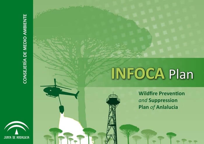
Additionally, if you live here already and have any concerns as to what is being done to prevent wildfires, be sure to download the Andalucian Government's document: Wildfire Prevention and Suppression Plan of Andalucía
Coín's fire history in context
Is Coín safe from forest fires in Spain?
The fairest answer is that Coín has a favourable recent historical record.
However, in August 2012, a major fire began in the municipality of Coín and spread across Coín, Alhaurín el Grande, Mijas, Marbella, Ojén and Monda. It affected 8,225.1 hectares of forest, agricultural and urban land, caused one death and led to the evacuation of more than 5,000 people. Investigators concluded that it began with a negligent burning of vegetation during extreme fire conditions.
It demonstrates that an exceptional fire is possible when ignition, hot dry weather, wind and continuous vegetation combine. It does not, however, demonstrate that Coín has suffered repeated disasters. More than a decade has passed without a comparable incident originating in the municipality.
What the latest 10-year local record shows
The period below is 2015-2024. It is the latest complete 10-year period for which official province-level statistics and sufficiently detailed local incident reporting could be reviewed together.
Table 1: Guadalhorce Valley and Málaga context, 2015-2024
| Year | Guadalhorce location or nearest relevant comparator | Recorded municipal incidents | Area burned | Main finding | Evacuation or property impact |
|---|---|---|---|---|---|
| 2015 | Guadalhorce municipalities | Not published | Not published | No major valley incident identified in reviewed sources | No major impact identified |
| 2016 | Guadalhorce municipalities | Not published | Not published | No major valley incident identified | No major impact identified |
| 2017 | Guadalhorce municipalities | Not published | Not published | No major valley incident identified | No major impact identified |
| 2018 | Guadalhorce municipalities | Not published | Not published | No major valley incident identified | No major impact identified |
| 2019 | Guadalhorce municipalities | Not published | Not published | No major valley incident identified | No major impact identified |
| 2020 | Guadalhorce municipalities | Not published | Not published | No major valley incident identified | No major impact identified |
| 2021 | Málaga province, outside the valley | Not applicable | 8,401 ha at Sierra Bermeja | Serious provincial fire, but not a Guadalhorce Valley fire | 2,670 people evacuated and one firefighter died |
| 2022 | Coín, Alhaurín el Grande and Alhaurín de la Torre | Local annual count not published | Coín area not published; Sierra de Mijas 612 ha | Río Grande fire extinguished the same day; major Sierra de Mijas fire affected the valley's southern edge | Preventive evacuations during the Sierra de Mijas fire |
| 2023 | Guadalhorce municipalities | Not published | Not published | No major valley incident identified | No major impact identified |
| 2024 | Alhaurín el Grande | One clearly documented local incident | 2.5 ha, provisional | Scrub and cane fire near Río Fahala | No evacuation highlighted |
Sources: Junta de Andalucía, INFOCA and documented incident reporting.
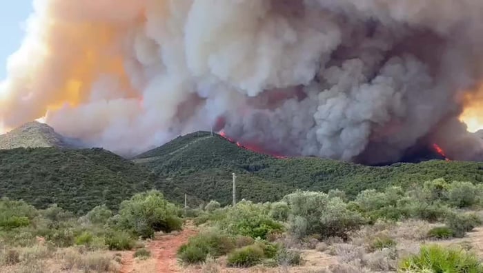 Source: Sur In English
The Sierra de Mijas fire
The most significant recent fire directly relevant to the southern side of the valley occurred in July 2022.
The Sierra de Mijas fire burned 612 hectares across Mijas, Alhaurín el Grande and Alhaurín de la Torre. It reached areas where mountain vegetation and residential development meet, leading to preventive evacuations.
This was a serious event and should not be minimised. However, it did not affect Coín, Cártama, Álora, Pizarra or Valle de Abdalajís, and it should not be presented as though the entire Guadalhorce Valley burned.
By comparison, the 2021 Sierra Bermeja fire affected 8,401 hectares across seven municipalities west of the valley. It forced 2,670 people to leave their homes and claimed the life of an INFOCA firefighter. Its extreme behaviour was linked to difficult terrain, adverse weather and pyrocumulus development.
These geographical distinctions are essential when assessing wildfire risk in Málaga.
Málaga compared with other Spanish property markets
A perfectly like-for-like comparison is difficult because Spain's consolidated fire database is not published at the same level or speed for every municipality.
The most consistent territorial comparison currently available uses consolidated MITECO EGIF data for 2015-2021. Málaga province is used as the closest reliable proxy for the Guadalhorce Valley, although the two must not be treated as identical.
Table 2: Comparison with selected Spanish buyer markets, 2015-2021
| Area | Recorded fires | Area burned | Hectares burned per 100,000 ha of territory | Large fires | Buyer-market context |
|---|---|---|---|---|---|
| Málaga province | 555 | 11,515.6 ha | 1,576 | 1 | Nearest reliable proxy for the Guadalhorce Valley |
| Valencia province | 1,096 | 9,173.7 ha | 849 | 4 | Mediterranean market with coastal and inland buyer areas |
| Murcia region | 757 | 1,864.8 ha | 165 | 0 | Popular warm-climate residential market |
| Girona province | 596 | 902.8 ha | 153 | 0 | Wider Costa Brava market comparator |
| Balearic Islands | 605 | 1,218.0 ha | 244 | 0 | Mallorca, Ibiza and Menorca market |
| Galicia | 13,783 | 124,826.5 ha | 4,221 | 41 | High-incidence national benchmark |
Underlying historical data: MITECO EGIF. Territorial summaries and methodology are presented separately from provisional 2022-2026 figures.
Málaga's figures are heavily influenced by one exceptional year. In 2021, 9,350.6 of the province's 11,515.6 hectares for the entire seven-year series were recorded, largely because of Sierra Bermeja.
This is why the figures should not be used to claim that Málaga is safer than every competing Spanish property market. They show that Málaga has experienced serious outlier events, but they do not show that every municipality within the province carries the same risk.
Spain's difficult 2026 wildfire season
MITECO's provisional bulletin recorded 61,163.21 hectares burned and 18 large forest fires between 1 January and 12 July 2026. That was more than twice the area recorded by the equivalent point of 2025. The ministry stresses that current-year totals remain provisional and may change as regional reports are checked and fire boundaries are measured more accurately.
The situation worsened considerably later in July. By 27 July, Copernicus EFFIS data cited by El País recorded 207,257 hectares affected by 366 fires of at least 30 hectares. This figure is not directly comparable with MITECO's earlier bulletin because the date, threshold and methodology differ.
Large fires in Ávila, Madrid, Toledo and Castellón led to extensive evacuations, road closures and emergency deployments. These events have caused real loss and distress for residents, and the work of firefighters, forest crews, the UME, police, civil-protection services, medical teams, volunteers and local authorities deserves recognition.
They should not, however, be used to suggest that every Spanish property destination has faced the same conditions.
Within the Guadalhorce area, a fire reported at Río Fahala in Alhaurín el Grande on 14 July was controlled that evening and declared extinguished the following day. The reviewed report did not identify a major evacuation or a large affected area.
Why some fires become severe
A fire's cause is not the same as the reason it becomes large.
An ignition may result from negligence, machinery, power infrastructure, deliberate action or, less commonly, lightning. MITECO has historically estimated that most Spanish forest fires are connected to human activity.
Whether that ignition develops into a major emergency depends on several other conditions:
- High temperatures and low humidity
- Dry soil and vegetation
- Strong or changing winds
- Steep terrain
- Continuous scrub or forest fuel
- Fine grass produced after wet winter or spring weather
- Limited road access
- Homes situated directly beside unmanaged vegetation
AEMET reported that June 2026 was mainland Spain's second warmest and third driest June since records began in 1961. The average temperature was 3.2°C above the 1991-2020 norm, while rainfall reached only 39% of the usual June total.
AEMET's current fire-danger index therefore considers temperature, wind, humidity and recent rain alongside vegetation condition, soil moisture, land use and surface type.
Andalusia faced an additional complication in 2026. Heavy early-year rainfall encouraged substantial vegetation growth. Once temperatures rose and that vegetation dried, it provided a larger volume of fine fuel capable of carrying flames quickly. The Junta introduced additional silvopastoral measures partly in response to this problem.
What buyers should check
Broad statistics cannot determine whether a particular home is exposed.
Town-centre properties
A townhouse or apartment within Coín, Cártama, Álora or Pizarra usually benefits from established roads, nearby emergency access, fewer continuous areas of combustible vegetation and several possible exit routes.
Edge-of-town villas
These can combine urban access with nearby scrub, agricultural land or wooded slopes. Buyers should check what lies immediately behind and below the property, not simply the address.
Rural fincas
A finca surrounded by olive, citrus or open agricultural land may have a different exposure from one beside pine forest, dense scrub or a steep ravine.
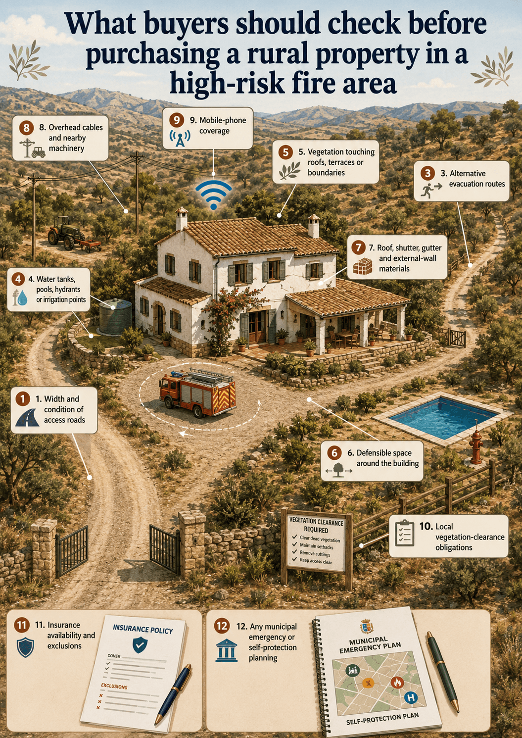
Before buying, examine:
- Width and condition of access roads
- Whether a fire engine can turn near the house
- Alternative evacuation routes
- Water tanks, pools, hydrants or irrigation points
- Vegetation touching roofs, terraces or boundaries
- Defensible space around the building
- Roof, shutter, gutter and external-wall materials
- Overhead cables and nearby machinery
- Mobile-phone coverage
- Local vegetation-clearance obligations
- Insurance availability and exclusions
- Any municipal emergency or self-protection planning
Insurance should be investigated before committing to the purchase. Rural homes can generally be insured, but price, excesses and exclusions may depend on construction, occupancy, access, surrounding vegetation and distance from emergency services.
A balanced conclusion for property buyers
The historical evidence should not give prospective buyers concern about buying property in Coín or the wider Guadalhorce Valley.
The area has experienced fires, including a serious exceptional event in 2012 and a significant valley-edge fire in the Sierra de Mijas in 2022.
However, the recent record does not show a continuing pattern of major destructive wildfires affecting Coín, Cártama, Álora, Pizarra, Valle de Abdalajís or the valley as a whole. National wildfire emergencies and large fires elsewhere in Málaga province should not automatically be applied to every home in inland Málaga.
The most accurate conclusion is that the Guadalhorce Valley remains a safe and sensible property-buying location, with a reassuring recent history. For most buyers, wildfire should be treated as a normal due-diligence issue rather than a reason to avoid the area.
Sources and research notes
- MITECO - General Forest Fire Statistics and EGIF methodology. Official national fire database and statistical methodology. Accessed 29 July 2026.
- MITECO - Provisional forest-fire advances. Current-year national figures and limitations. Accessed 29 July 2026.
- Junta de Andalucía - INFOCA annual statistics. Province-level annual incident and area data. Accessed 29 July 2026.
- Junta de Andalucía - Sierra de Mijas emergency restoration report. Published 4 October 2022. Accessed 29 July 2026.
- Junta de Andalucía - Sierra Bermeja final incident report. Published 24 October 2021. Accessed 29 July 2026.
- Europa Press - Río Grande fire in Coín. Published 20 September 2022. Accessed 29 July 2026.
- Europa Press - Alhaurín el Grande fire. Published 14 September 2024. Accessed 29 July 2026.
- Europa Press - 2012 Málaga fire. Published 4 September 2012. Accessed 29 July 2026.
- AEMET - June 2026 climate summary. Published 7 July 2026. Accessed 29 July 2026.
- AEMET - IPIF forest-fire danger index. Published 28 May 2026. Accessed 29 July 2026.
- Junta de Andalucía - 2026 silvopastoral wildfire-prevention measures. Published 29 April 2026. Accessed 29 July 2026.
- MITECO EGIF territorial summaries. Málaga, Valencia, Murcia, Girona, Balearic Islands and Galicia, consolidated 2015-2021 data. Accessed 29 July 2026.
FAQs
Is Coín safe from forest fires?
Coín has a reassuring recent record and has not suffered repeated major fires during the latest decade reviewed. It is not risk-free, and the exceptional 2012 fire remains relevant, but the history should not discourage buyers from considering the town.
Is the Guadalhorce Valley considered a high-risk wildfire area?
The evidence reviewed does not place the valley among Spain's most persistent high-incidence wildfire areas. Exposure varies considerably between urban centres, agricultural land, wooded hills and isolated rural properties.
Have there been serious forest fires near Coín?
Yes. A major fire began in Coín in 2012, outside the main 2015-2024 review period. The Sierra de Mijas fire in 2022 also affected Alhaurín el Grande and Alhaurín de la Torre.
Was the Sierra Bermeja fire in the Guadalhorce Valley?
No. Sierra Bermeja is elsewhere in Málaga province, west of the Guadalhorce Valley. Its statistics should not be presented as Coín or valley statistics.
Are rural fincas more exposed than town properties?
They can be. Isolation, vegetation, narrow roads, steep slopes and limited water access may increase exposure. A well-maintained finca surrounded by agricultural land may still have a manageable risk profile.
Is it safe to buy a finca in inland Málaga?
Yes, provided the individual property is properly assessed. Buyers should check access, surrounding vegetation, water, construction, evacuation options and insurance before purchasing.
Can overseas buyers insure rural properties?
Insurance is generally available, but policies and exclusions vary. Obtain written quotations before exchange or completion, especially for isolated or forest-edge properties.
What should I check before buying?
Inspect road access, escape routes, nearby vegetation, slopes, water storage, roof materials, mobile coverage, overhead cables and the maintenance of neighbouring land.
How quickly does INFOCA respond?
There is no guaranteed universal response time because access, terrain, weather and simultaneous emergencies differ. However, Andalusia's high proportion of fires contained below one hectare indicates that rapid initial intervention is frequently successful. In the 2025 high-risk season, nearly 80% of INFOCA's forest interventions remained conatos, meaning they affected less than one hectare.